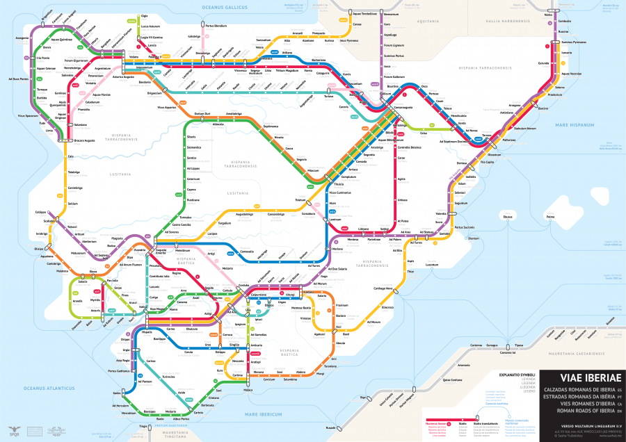
In a fascinating blend of ancient history and modern design, statistics student Sasha Trubetskoy has visualized the Roman roads of Portugal and Spain as a subway map. This innovative project not only highlights the extensive network of roads built by the Romans but also emphasizes their significance in connecting distant lands during the Roman Empire.
The Roman Roads: A Historical Overview
Between the first century BC and the fourth century AD, the Roman Empire constructed an extensive network of roads that facilitated trade, military logistics, and cultural exchange. These roads were engineered with remarkable precision, allowing for efficient travel across vast distances.
The Antonine Itinerary, a key source for understanding these routes, consists of 225 lists detailing stopping points along various Roman roads. Each entry provides information on the start and end of routes, total mileage, and intermediate points, offering a glimpse into the organized nature of Roman infrastructure.
The Subway Map Concept
Sasha Trubetskoy’s subway map of the Roman roads of Iberia transforms the historical data from the Antonine Itinerary into a visually engaging format. Here are some highlights of the project:
- Visual Representation: Each route from the Antonine Itinerary is depicted as a distinct line on the subway map, making it easier to understand the connections between different locations.
- Creative Challenges: Trubetskoy faced challenges in accurately placing certain routes due to ambiguities in historical records. He supplemented his work with archaeological evidence to ensure a comprehensive representation.
- Modern Appeal: By using a subway map format, Trubetskoy bridges the gap between ancient history and contemporary design, making the information more relatable and engaging for today’s audience.
The Importance of Roman Roads
The Roman roads were more than just pathways; they were vital arteries of the empire that facilitated:
- Trade: Goods and resources flowed freely, boosting the economy.
- Military Movement: Troops could be deployed quickly to various regions, enhancing the empire’s security.
- Cultural Exchange: The roads allowed for the spread of ideas, languages, and cultures across vast territories.
Conclusion
Sasha Trubetskoy’s subway map of the Roman roads of Portugal and Spain serves as a remarkable reminder of the ingenuity of Roman engineering and the interconnectedness of ancient societies. By reimagining these historical routes in a modern context, Trubetskoy not only honors the legacy of the Roman Empire but also invites a new generation to explore and appreciate the significance of these ancient pathways.

